page 1
The Hodgkinson Goldfield, Northern Queensland.
BY THE REV. J. E. TENISON-WOODS, F.G.S., F.L.S.; HON. MEM. ROY. SOC., N.S.W., TASMANIA; COR. MEM. ROY. SOC., VICT.; PRES. LINNAEAN SOC., N.S.W., &c., &c.
[Read April 15th, 1880.]
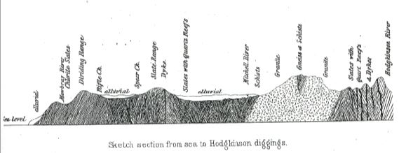
The portions of the colony of Northern Queensland dealt with in this paper are the goldfields of the Hodgkinson, Walsh, and Mitchell Rivers, all of which streams drain into the Gulf of Carpentaria, on its eastern side. I give, also, a sketch of the country between these fields and the east coast, following the bridle track between Port Douglas and the diggings. Port Douglas is an anchorage at the mouth of a small mangrove creek, between the mouths of the Mossman and Mowbray Rivers. It is sheltered by a small peninsula, called Island Point. This is about a mile in length, and rises rather abruptly to a height of 200 feet above the sea. Its greatest length lies parallel with the coast, and it is scarcely a quarter of a mile wide, being, in fact, a mere ridge. It is composed of a metamorphic rock. The almost vertical dip of the strata can still be seen, as well as the almost north and south strike. In some places it is a coarse felspathic rock, like porphyry, with large crystals of hornblende and felspar. In addition to this, there are long streaks or irregular bands of black hornblendic rock, which pass through the line of stratification. The appearance is like streaks of pitch, and it is very vesicular; but whether that was its original state or due to the weathering action of the sea, where the rock is exposed, cannot be well made out. I should be inclined to describe it as a trap breccia, and the dark masses as more augitic than hornblendic. It may be one of those numerous as beds or trap conglomerates which are so common in the silurian formation, to which period, from the dip and strike and general appearance, I suppose it to belong. It has certainly been subjected to metamorphic action since it was upheaved to its present vertical dip. I regard the peninsula itself as a former island only very recently reclaimed from the sea. At the land side, the hill slopes down to a wide and marshy mangrove creek. The intervening country between Island Point and the main
page 2
range is a level plain, one to three miles wide, covered with an open forest of Wormia alata, Thespizia populnea, Heritiera littoralis, Careya arborea, Acacia holoserica, Pandanus pedunculata; but the tree which prevails to the greatest extent is Melaleuca leucodendron, or paper bark tree, as it is called. As far as sections from rivers and creeks will enable one to judge, the plain is composed of an alluvial detritus from the main range, fringed by a bank of sand, which is derived from coral banks and the disintegration of the stone. There is a series of low coral islands about eight miles from the shore, some wooded, and some mere sandy patches, almost submerged at low water. The outer Barrier Reef is nearer to the coast here than further north and south, and from the summit of the dividing range can be seen plainly.
Proceeding in a southerly direction from the peninsula, or Island Point, as it is called, the mouth of the Mowbray River is crossed at about three miles. The interval is occupied by a hard, sandy beach, on which no rock shows. This beach is fringed by a very dense vegetation, in which Wormia alata, Ficus macrophylla, and Thespizia populnea hold the principal place, bound together by the common climbing cane, Flagellaria indica. At the back of the ridge, the mangrove creek already referred to holds its way for a long distance. In my track across the main range, I followed the course of the Mowbray to the ford. It is a narrow, tidal stream, with a fringing reef of coral, extending out to sea about four miles on one side of its mouth. Its course from the range is very short, and it can be seen coming over the divide in many long falls of white foam. As the east side of the range is in general very precipitous, a large number of these falls can be seen at every opening. Some of them are of considerable extent, and in the rainy season, whenever the weather is clear enough, the cascades form beautiful adornments to the scenery.
On the east side of the divide the vegetation is very thick, and it is only in one or two places that sections of the rock are exposed. All that I saw were highly inclined chloritic slates, rather similar in appearance to the strata on the ranges near Glen Osmond, Adelaide, and which has been so largely used for building purposes in that city. The road ascends with great rapidity, the inclines being quite as steep as any on the spurs of the divide near Sydney. The height of the crossing-place of the road to the Hodgkinson is about
page 3
1700 feet, as told by my small aneroid. All west of this is western water, and flows into the Gulf of Carpentaria by the Mitchell River. The distance by road is about twelve miles; but in a straight line, probably not more than eight from Port Douglas. To the south of the crossing-place is a large hill, Mount Harris, which is called the Black Hill by the settlers in the neighbourhood. It is about 2200 feet high, And, as there are other hills with the name of Harris attached to them, there is some confusion about this. It is a remarkable object, as from one side of it the river Mowbray descends to the east coast, and from another, Rifle Creek, which joins the Mitchell, and flows into the Gulf of Carpentaria.
Rifle Creek is crossed at about three miles on the west side of the divide. It is a very deep and rapid stream, with precipitous banks, densely clothed with scrub, but not showing any outcrop of rock. Five miles further, Spear Creek is crossed. This is another tributary of the Mitchell. The intervening country is a plain of table-land, evidently subject to inundation, with a marshy surface, and no outcrop of rock. It is, about 1400 feet above the sea level. After crossing Spear Creek, which is wider and more shallow than Rifle Creek, the country becomes undulating, and soon broken by the precipitous spurs of what is called the Slatey Range. This is entirely composed of slate rocks, with a dip and strike, and lithological character very similar to the lower silurian rocks throughout Australia. Quartz reefs occur in them, and in the gullies there have been formerly small alluvial workings, but the ranges have not been carefully prospected. These ranges are a series of very steep ridges, and consequently the creeks descending from them are nearly always dry. The soil is light, and supports a poor vegetation, principally stunted gum trees, coarse grass, and a few grass-trees. There is no scrub, but it is rather remarkable that at the summit of these ridges, at about 1700 feet above the sea, Eucalyptus maculatus occurs, and possesses that strong odour of lemon thyme which this species seems to have only when found in the tropics. The same tree is the commonest on the east side of the dividing range from Cape Howe to a considerable distance beyond Moreton Bay. The variety with the lemon scent is only found in the tropics and upon the ridges, and goes by the name of E. citriodora, being considered as a distinct species in the Flora Australiensis. I intend to publish a few notes separately on this remarkable variety.
page 4
Descending from the ridge, the level of the table-land is again reached, and this, as I have said, is about 1400 feet above the sea. The slate ranges are crossed quite unnecessarily. It is merely a spur from the south-west, belonging to the main range or divide, and Rifle Creek, after being joined by Spear Creek, flows round the north end of it to join the Mitchell. By following the course of Rifle Creek, after crossing the divide, the slate range must consequently be entirely avoided.
The valley of the Mitchell is an open plain, about ten miles across. The soil is poor and somewhat marshy, and the vegetation consists of open forest of Melaleuca leucodendron, Eucalyptus platyphylla, and E. hoemastoma and Petalostigma quadriloculare. The grass is luxuriant and abundant. The whole flora does not differ in any very striking manner from the open plains on the east side of divide, except in the absence of strictly littoral species, which the distance from the sea must lead us to expect. In this respect the upper valleys of the Carpentaria waters differ from all others on the western side of the Australian Cordillera which I have visited. Farther south, a most marked difference is seen between the vegetation of the eastern and western slopes of the watershed.
No section throwing any light on the geology of these plains is obtained near the crossing-place of the Mitchell. The banks are not steep, and they consist of alluvial detritus from the stream and beds of sand. The river itself, a fine broad, shallow stream of clear water, is always running. It is flooded in the rainy season, and is then difficult and dangerous to cross. The ford on the Hodgkinson track is between 300 and 400 miles from its mouth, in a straight line, so the importance of this river can be thus estimated. At the crossing-place it is about sixty yards across, and the running water in the driest seasons about one-third of that width. The East and West Hodgkinson, the Palmer, the Walsh, and many other streams, join the Mitchell in its course. When near the sea, it is a very broad and deep channel, but not much is known of it. Mr. Bartley Fahey, the Harbour-master at Cooktown, explored a good deal of its course, entering by its sea mouth. As well as I remember, he was able to sail up for about sixty miles. The natives were extremely numerous and hostile, which is their character for the whole course of the stream. As might be expected, crocodiles are also very numerous.
page 5
After crossing the Mitchell, the road traverses the plain for about three miles, and then commences to ascend a granite range. This is another spur from the divide, and the Mitchell passes round its northern end, so that it is crossed quite unnecessarily. The explanation of this is, that when the Hodgkinson Goldfield was explored, it was reached from Cooktown; and then a further exploration was made to find the sea coast and some more convenient port of shipment than Cooktown. The object of the explorers was to reach the coast in the straightest possible line, and thus they passed over many ranges which a better acquaintance with the geographical structure of the country will enable them to avoid.
The character of the range is exceedingly bold and picturesque. Huge boulders and bare surfaces of granite are very conspicuous. The crossing-place is over 2000 feet above the sea level; but to the south it rises to a height of between 3000 and 4000 feet. To the north-west, dark masses of still greater elevation are seen; but they are divided from this track by the valley of the Mitchell. The whole of this granite series, with numerous spurs, offshoots, and isolated ranges, belong to one formation, which probably has its greatest height in the Peter Botte Mountains, halfway between Cooktown and Port Douglas, and fifty miles from the coast at Cape Tribulation.
In ascending the range the cuttings made for the road enable one to see very good sections. The metamorphic character of the granite is beautifully shown. Slates, with a vertical dip, clothe the sides of some of the spurs. They are seen to pass gradually into schist, highly contorted, and then into gneiss, and finally into the hard, compact blue and grey granite of the range. Here and there are seen sections of granite, with small patches of slate, not completely transmuted, lying in the mass. It is thus abundantly evident that this granite is only the altered slates. It may be that the strata thus transmuted are a portion of the formation at the Slate Range and the auriferous slates of the Hodgkinson field. This cannot be asserted positively, though it is extremely probable. Remembering this, and that the reefs at Charters Towers and Ravenswood are both found in syenite, there is no reason why these immense formations at the Hodgkinson should not be auriferous also. In the transmutation of the stone from slate into granite many quartz veins are found; but I am not aware of any reefs, properly speaking.
page 6
The vegetation of the granite range is peculiar, and not like that of the plains or the slate ranges. It is often a scrub; but it must be remarked that there are two distinct kinds of vegetation to which, in this part of Queensland, the term is applied. One is the river scrubs, with a dense and very luxuriant growth of palm trees, vines, tree ferns, nettle trees, Calophylla, and tropical vegetation generally. Another is a thick, entangled growth of Acacia, Vitex, dwarf Eucalypti, and shrubs, none of which grow into trees, but spread out into twiggy bushes. The latter kind of scrub is only found in poor, sandy, or clay soils, dry, and in ridges where the water does not rest. This is the vegetation found on the granite range. The Eucalypti are stunted, and ferns rather numerous under the rocks. I regret very much that I was not able to make any collection while on the range. I was alone and unarmed, and could not safely venture off the track for the purpose of botanising. The distant ledges of granite, with their bushy surroundings, were very tempting; but I was obliged to leave them. There were no signs of natives about; but in the short history of this part of the world there are so very many sad illustrations of how the neglect of prudent precautions has resulted in loss of life, that one additional example in my case was not needed.
When the granite range is crossed, the track descends rapidly to a very broad, shallow stream, called the East Hodgkinson. It is principally conspicuous for its bed, which is made up of wide sheets of loose granite detritus, in which belts of Casuarina equisetifolia were growing. The level of all these streams is about the same; that is; between 1300 and 1400 feet above the sea. It is remarkable that the farther these rivers are from the coast they are less thickly lined with scrub. Those near the ocean are densely wooded, and those far from it, such as the West Hodgkinson, have scarcely any more vegetation on the banks than is seen on the ridges.
From the side of the East Hodgkinson the land is a succession of very steep, somewhat barren ridges of silurian slate, clothed with an open forest of Eucalyptus corymbosa, Eucalyptus platyphylla, E. hoemastoma, Grevillia robusta, and some other trees, all of a poor kind. The ridges vary in height from 2000 to 2600 feet above the sea. At about ten miles from the East Hodgkinson the Western Hodgkinson is crossed. The whole intervening country is more or less
page 7
intersected with quartz reefs. The township of Kingsboro, or what is strictly termed the Hodgkinson Diggings, is at the crossing-place of the river. Like all new diggings in very remote places, it is extremely primitive in its architecture. The residents endeavour to do with as little as possible in the way of shelter and accommodation, yet, notwithstanding this and the extreme heat of a tropical climate (lat. 16° S.), the place is not unhealthy. The town is on a small ridge, about 1700 feet above the sea, but above and around it there are many peaks and elevations, rising abruptly to considerably over 2000 feet. The soil is not barren, being a reddish earth, but too steep and stony to be favourable for agriculture. The Hodgkinson winds around the town. It is never quite dry, but does not run all the year round. It is a shallow, rocky stream, with thin belts of bushes in its bed, and with very little alluvial detritus. There are boulders and water-worn stones in abundance, amid which the Chinese get small amounts of gold by cradling and sluicing; but, as it was the dry season at the time of my visit, there was very little of this going on.
Around the town many claims are visible, but not all of them working. The most successful were the Tyrconnell and the Grattan, both close to the town. Two conspicuous peaks close by have the Laird of the Hills and the Great Britain claims upon them. The first is a very elevated, narrow, almost peaked mountain, about 2100 feet above the sea. The rock exposed on the surface is entirely ribbon jasper and agate, of beautiful, interesting, and perhaps valuable structure. The quartz vein crops out near the summit. It has a north and south strike, and a considerable dip to the east. The quartz is a very wide seam, of rather favourable appearance. It has not been worked as yet profitably; but I think more for want of means and appliances than from the poverty of the stone. The Great Britain claim is on a lower peak to the southward. It seems a continuation of the vein which is worked so profitably at the Tyrconnell, but it does not show very payable results. The reef seems to be in close contact with a dyke, and is probably intersected by it. And here it may be as well to state that dykes of the stone to be described are very common on the whole of the field. They are igneous intrusions, but of a character difficult to arrange with any well-known form of intrusive rock. It is a dull bluish grey paste, enclosing a black mineral, which is found in
page 8
large angular or rounded patches. There are also small fragments of white quartz and felspar, with almost a stratified appearance. In fact, the stone at first would be certainly taken for a conglomerate. The black masses I suppose to be hornblende. I have not been able to make any microscopic examination of sections of this rock, which I should think has acquired its present appearance by metamorphism. It is clearly an intrusive rock, as its appearance amongst the vertical slates and the way it cuts off the reefs show. I remarked that the black crystals are very similar to the peculiar black and pitch-like portions of the trap breccia at Port Douglas, and I think it must belong to the same formation.
The strike of the slates is about a point E. and W. of N.E. and S.W. This is very nearly the direction of all the ranges hereabouts. The dykes seem to follow the strike of the strata. The ranges are short, and divided by deep passes. There are many in parallel lines, and the sides are scored by many precipitous gullies. The strike of the reefs is nearly north and south, and therefore the edges of the slate strata abut diagonally upon them. The reefs consequently do not follow the line of the ranges, but cross them. The slate is very fissile at the outcrops, which are not numerous. At the Tichborne claim it passes into a hard flagstone, and at moderate depths is found to pass into beds of very black, shining talcose slate, and thence into black limestone. There can be but little doubt that in these slates we have a series of folds in which the same strata are often repeated in the anticlinal and synclinal flexures. There is no good natural section to enable one to judge of the exact position of the black limestone. It is found very abundantly, with numerous veins and strings of white calcite, and in the form of marble at the Grattan reef, which is a very rich claim; and the vein stone of quartz with gold is being worked now in the limestone country. As far as I could learn, no traces of fossils have been found in any of the slates, and, considering the evidence of disturbance and metamorphism that is here offered, it is very unlikely that any will be found. There are many geologists who regard limestone strata as of entirely organic origin, and most probably, should any fossils be discovered, they will be in the neighbourhood of these rocks. The black and shining appearance of the stone has induced many to think there were indications of coal, which the black
page 9
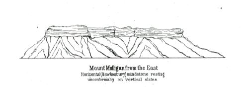
hornblendic fragments in the dykes seemed to favour, as they are not unlike fragmentary plant impressions. No positive assertion can be made as to the age of these slates; but their resemblance to the Victorian auriferous strata, their lithological character and vertical dip, render it extremely probable that they are of lower silurian age. The parallelism of the dip of the strata, or rather folds, and the general direction of the ranges, render it probable that we have in the physical features of this country the few remaining relics of the corrugations or folds into which the earth's crust shrank subsequent to the lower silurian period. But we have evidence that there have been immense changes since. In the accompanying figure of Mount Mulligan, about twelve miles from Thornboro, we have another relic, but of a different kind, of the former geological history of the country. This is an isolated mass of tableland, the summit of which is composed of about 600 feet of horizontal sandstone, exactly like the Hawkesbury sandstone, as it is seen at the Port Jackson Heads or along the railway line over the Blue Mountains. From the occurrence of the formation at Mount Mulligan and numerous other places on the coast, there can be but little doubt that this horizontal sandstone once covered immense tracts of north-eastern Australia; but it is only seen now in isolated patches, all the rest having been completely denuded away. I cannot offer any direct evidence that the Mount Mulligan sandstones are the equivalents of the Hawkesbury sandstone, because I was not able to examine them closely; but lithologically there is no difference, and similar outlying patches are known to contain vegetable impressions, connecting them with the formation in New South Wales. It will be seen by the sketch annexed that the sandstone rests unconformably upon the upright edges of the vertical slates. These slates are full of quartz reefs, some of which are worked for gold.
I would here call attention to the large number of inferences which can be drawn from the Mount Mulligan formation. It is obvious that the silurian rocks were not only deposited but contorted so as to be tilted to their present vertical dip before the sandstones were deposited upon them. The quartz reefs were also formed on them. But we know from the geological record elsewhere that an immense number of formations and a number of distinct epochs intervened between the slates and the age of the
page 10
Hawkesbury strata. Thus the upper silurian formation, with its peculiar forms of life, the lower, middle, and upper Devonian, the lower and upper carboniferous strata, are all wanting, with probably others which I do not specify, so as not to define the age of the Hawkesbury beds too closely. All these formations represent distinct animal and vegetable fauna and flora. They may not all of them have been deposited on the slates, but it is extremely probable that some of them were, and to the extent of many thousand feet of rock. They have come and gone, and very few traces of them remain. Slow as the process must have been which removed them, slower still must have been their gradual deposition. Then, again, the Hawkesbury sandstone itself has accumulated to the thickness of at least 2000 feet, and it has left no traces of its former existence except a few outliers, such as Mount Mulligan. We have no evidence here of the changes to which the beds have been subjected during the mesozoic and cainozoic periods, or how much of these rocks may have overlaid them, but that they have been in the place where we find them during that long, untold period of the earth's history. The ranges and the folds of the strata are anterior to the sandstone, and so are the veins, but they are not contemporaneous. The dykes are the last parts of the history of the strata, but they do not penetrate the sandstone. The whole subject of the geological changes evident in Northern Queensland cannot be dealt with in this paper, so I shall not pursue the obvious conclusions suggested by the interesting features of this auriferous region.
The Hodgkinson Goldfield is estimated to about 600 square miles, but probably this is much below the truth. Up to the end of the year 1878 there were 330 reefs proved to be auriferous, and this also must be below the truth, though some of the reefs looked upon as distinct belong to one and the same. It has never been much of an alluvial field. In this respect it offers a remarkable contrast to the Palmer diggings, which has been always richest in alluvial gold. The latter covers an area of about 2000 miles, with only 112 known reefs. The alluvial finds in the field were enormous; but now that this is beginning to be worked out the population has decreased. The gold reefs on the Hodgkinson are not exceeded in the number of reefs by any field except Charters Towers and the Etheridge and Gilbert, and in the yield of gold it exceeded, in 1878, every field
page 11
except the Palmer and Charters Towers. Its gold is, however, of poorer quality, being only worth, on an average, in 1878, £3 8s. per ounce. The Palmer gold is almost pure, being worth £4 2s. 6d. In Queensland generally the gold is much alloyed with silver, and if the Palmer is an exception, it must be remembered that the average was taken principally from alluvial gold, which is generally nearly pure. Only 8233 ounces was of reef gold, out of 120,233 from the Palmer, while at the Hodgkinson 44,435 ounces, exported in 1878, contained about 4000 ounces of gold from alluvial sources. The Hodgkinson gold is pale in colour, and much alloyed with silver. Other metals are present in small quantity, such as copper and antimony, but in the assay only the silver is estimated. Iron and lead show traces in some mines, and there is a little sulphur, and sometimes arsenic. In a specimen taken by me from the Explorer reef, I saw blue and green carbonates of copper (azurite and malachite), sulphide of iron, sulphide of copper, and carbonate of iron and lead. The carbonates, no doubt, were derived from the carbonate of lime in the strata.
The average yield of the gold quartz from the Hodgkinson is per ton 1 oz. 11 dwt. 3 grs. In the Palmer the average is higher, being 2 oz. 13 grs.; but the average is taken from smaller parcels in the latter case - about one-fifth of the quantity crushed on the Hodgkinson. The yield had decreased on most of the diggings in 1878 from what it was in 1877. The cost of crushing is about £1 per ton at both diggings, but at Ravenswood the price charged is about 7s.; yet the miners' wages averaged higher in 1878 on the Hodgkinson than any other diggings except Charters Towers.
The quartz veins on the Palmer River are in silurian slates. There are no dykes like those on the Hodgkinson, but there is a very slight capping at one place of what may be considered a trap rock, probably tertiary, and like phonolite. At Gympie the gold is in Devonian or lower carboniferous slates, with fossils and dykes of diorite. The dykes at the Hodgkinson are entirely of a different character, and not in the least like the diorites of Gympie, which are very similar to those seen at Gaffney's Creek, in Victoria. In Charters Towers the reefs are worked in hornblendic porphyry and syenite, which is seen to be derived from altered slates. In Ravenswood a similar formation is worked for gold; but there can be no doubt that the
page 12
so-called reefs are mineral veins, which become, at the water level, true copper and zinc lodes, with a little gold.
The mining operations on the Hodgkinson are of the simplest and poorest kind. Few of the claims have been followed to any depth, and only where the stone has proved rich. The reefing has been entirely carried out by a few working men in small parties. It need hardly be said that mining can never be successfully carried out in that way. There was at the time of my visit only one winding and pumping engine on the whole field, and that is only a small one on the Rob Roy claim. There are only two whims erected. In fact, there are no systematic mining operations carried on in this very rich and extensive tract of auriferous quartz. As yet, capital has not been employed on this field, and it may scarcely be said to be prospected. The little quartz that has been extracted has been got out in a slow and most expensive way, for the most part in buckets by hand windlasses, and unless the stone had been really good it never could have kept so many men employed in this way, and with these appliances, for so long a time. There are 13 machines employed on the field, with an aggregate of 155 horse-power, and 121 stamp heads. There are no buddies. One great reason for the small number of appliances is the great expense of cartage to the field. The Hercules crushing mill at Thornborough was brought from the coast almost entirely on pack-horses, at a cost of £40 a ton, though the distance is not seventy miles by road. The most of the carriage is still done by pack-horses. The road is excessively steep on the seaward side of the coast range, and, even where it has been cut, impracticable for drays in wet weather. The expenditure of a small amount of money would easily remedy this. The great want of the field at present appears to be a good road, and with that capital will soon develop its resources.
As far as experience has taught the miners, the reefs have been found richer at the surface than deeper down. An opinion prevails among the miners that the gold is only found in " shoots," or particular lines of varying direction. Thus the gold in a reef is thought to be restricted to a very limited portion of the stone, and when this "shoot" is lost the reef is often abandoned. It is quite certain that the stone becomes suddenly poor in a great many instances. The miner is not able to expend much money in searching for it again, and thus many good claims are deserted. Some
page 13
have been taken up again by men of more means, and have been found to pay well. The Homeward-bound reef is a remarkable instance of this. There does not seem to me sufficient reason for the opinion that the gold is found only in " shoots." It very often happens that the miner rejects or crushes the stone for very arbitrary reasons, and some of what he throws away is often as rich as what he sends to the mills a.s part of the " shoot." An instance of this was related to me by Mr. Martin, the intelligent proprietor of the Hercules quartz mill. A parcel of stone was crushed by him for some miners, which yielded well. The miners then brought some more stone which they had put aside as of poor character. They would not run the risk of having it crushed unless at half profits. Mr. Martin took the stone on these terms, and it went higher than the other parcels, giving nearly 4 ozs. to the ton. For my own part, I do not believe in the "shoot" theory. The truth is, the miners cannot afford to crush all the stone they raise, and they pick out what seems to be the best, but are often mistaken in their estimate.
Some of the mining experiences have been most peculiar. In a claim which is on the summit of a hill, 300 feet above Thornborough, a very rich mass of stone was found. This was the celebrated reef which bore the ridiculous name of the "Flying Pig." After getting some distance down the stone became suddenly barren, though it had yielded 19 ozs. to the ton. It is easy to assign a reason for this. The surface of the reef contains the accumulation of the gold, which has dropped gradually down as the reef itself has weathered away. Seeing the immense amount of denudation that has taken place, and which has perhaps removed hundreds of feet of auriferous quartz, we might naturally expect some fragments of the golden detritus to remain entangled in the weathered surface and oxidized stone. It by no means follows, however, that the stone below will prove entirely barren, and a search as far as the water level is generally ' rewarded with better ore.
A question which concerns the miners of this field very much is that of the tailings. It is well known that the whole of the gold in the quartz does not get caught by the quicksilver, especially as some of the machines used are of a rough and imperfect kind. The gold thus missed remains in the tailings. I was informed that a fire assay of the tailings from one mill yielded as much as 6 ozs. to the ton. But the question is how to deal with them. A good deal of
page 14
the gold is very probably in the form of minerals which the mercury will not touch, such as combinations of sulphides, antimony, arsenic, &c. I have suggested roasting the quartz, and in some of the claims the ore would be much benefited by such a process. But I admit that the kind of roasting, and the amount of it, will have to be learned by experience, which, no doubt, will include many failures.
Upon the whole, I consider the Hodgkinson to be one of the most important mining districts in Queensland, because of its richness, its large extent, and permanent character. Being so near the coast - for the actual distance is under fifty miles - it possesses advantages over nearly every other field. What is wanted is a good, easy road, and when this is made, capital will soon take up the matter of fully developing the resources of a diggings, the ultimate success of which can only be a question of time.